 |
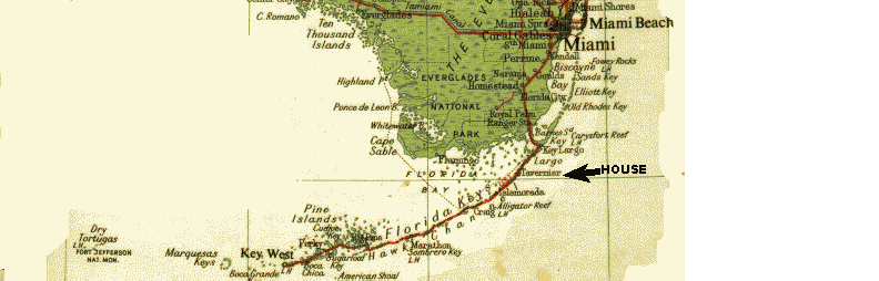
The house is located on Tavernier, on the south end of Key Largo, approximately 50 miles from Miami. A one hour leisure drive through the edges of the evergaldes, beautiful ocean views and coves. |
|
The house is located on Tavernier, on the south end of Key Largo, approximately 50 miles from Miami. A one hour leisure drive through the edges of the evergaldes, beautiful ocean views and coves. |
|
Below is a map of the Florida Keys highlighting the town of Tavernier, where the house is. You have access to the maps of each one of the regions as detailed below or on the menu at left.
How big are the Florida Keys? There are more than 800 keys, stretching over 290 km (180 mi.). The longest key, Key Largo, is 48 kilometers (30 mi.) long and 0.8 km (0.5 mi.) wide. Why are they called the "Keys"? The word "key" actually comes from the Spanish word cayo, meaning "little island." |
 |
Navigating in the Keys is really easy. There is a 127 mile (204 km) mainstreet called the Overseas Highway. This highway is the southernmost segment of U.S. Highway Number 1 which runs from Key West all the way to New England.
In the keys all addresses are refered to by MM (mile marker) which starts at 0 in Key West, so you will be 92.5 miles from Key West (MM 92.5). You'll see a small green and white sign every mile, by the side of the road with the number on it. This tells you the distance to the end of the road in Key West.
We want to show you maps of:
|
 |